 |
Extremadura - location and geography
The autonomous community of Extremadura lies in west-central Spain and should not
to be confused with the similar nearby area of Estremadura in SE Portugal.
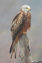
 Red Kite Milvus milvus
© John Muddeman
It borders Castilla y Leon,
Castilla - La Mancha, Andalucía and also Portugal
(to the W). Covering some 41634 km sq. it is comprised of two provinces: Cáceres
in the north and the slightly larger Badajoz to the south. Mérida on the Río
Guadiana and the border of these provinces is now the administrative capital.
Like the other main areas of extensive agriculture in Spain (Aragón, Castilla -
La Mancha and Castilla y León) the population is sparse and concentrated in a
few larger towns and cities, with an average density of 26 inhabitants / km sq.
This is a land of both sharp contrasts and subtle variations, rising from the lowest
point at c. 180 m a.s.l. by the Río Guadiana in the far south-east, up to c. 2400 m a.s.l.
in the Sierra de Béjar in the far north. In simple terms, the bulk is formed by undulating
plains sliced though by numerous mainly small rivers and streams and dotted around with
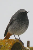
 Black Redstart Phoenicurus ochrurus
© John Muddeman
craggy peaks rising up at irregular intervals, but several mountain chains ("sierras")
are liberally scattered around. The impressive ridge of the western Sistema Central
(Sierra de Gredos, Sierra de Béjar, Las Hurdes and the Sierra de Gata) rises up like
a wall along the northern boundary and is easily seen from as far S as Trujillo.
Other important mountain ranges include the Sierra de San Pedro (W Cáceres),
Sierra de las Corchuelas (Monfragüe), Sierra de Montánchez (SC Cáceres),
the Sierras de Guadalupe and las Villuercas (E Cáceres), and the Sierras del
Algibe, de la Lobera, de la Rinconada and de la Solana (E Badajoz).
The N flank of the Sierra Moreno forms the southern boundary of Badajoz.
Numerous other important smaller sierras are also present, especially in Badajoz,
e.g. Sierra de Tiros, S. Grande de Hornachos, S. de Tentudia, etc.
Badajoz Province, despite having a more extensive and varied agriculture also has
large forested areas and important areas of pseudosteppe habitat, including the largest
single area of pseudosteppe in Spain: La Serena. Cáceres Province has a higher proportion
of forested habitats, but with a huge, partly interrupted arching belt of pseudosteppe
running from west of Brozas, eastwards through Cáceres, though Trujillo and reaching
Torrecillas de la Tiesa.
|